
Do you really need a dedicated map while visiting Dubrovnik? You might think your phone is enough. But considering the density of cultural monuments concentrated on a relatively limited surface inside the mighty city walls, having a proper map is essential.
Google Maps is obviously the go-to resource, but it has a major flaw here: the signal often bounces off the high stone walls in the narrow alleys, sending your blue dot spinning in the wrong direction. Plus, it doesn’t tell you which streets have 500 steps and which are flat.
I am here to share various maps of Dubrovnik that solve these specific problems, including a detailed tourist map, breakdowns of the Old Town, and the public transit network you’ll actually use.
Map of Dubrovnik Old Town

A detailed map of Dubrovnik’s Old Town highlighting the main attractions is the first thing you need to save. You can check my map above and refer to it whenever you need help finding one of the main monuments.
If you are more old school and you prefer a traditional paper map, you can pick up a free copy at any of the Information Offices of the Dubrovnik Tourist Board.
The primary office is located at Pile Gate, Brsalje 5 street (located here on Google Maps), open daily from 8 AM to 8 PM.
For those arriving by sea, free maps are available at Gruz Harbor, located at Obala Ivana Pavla II, N. 1 street (see here), with working hours from Monday to Friday, 8 AM to 8 PM, and on weekends from 8 AM to 2 PM.
Additional information offices are at the Dubrovnik Airport and, during the high season, on the Elafiti Islands of Lopud and Sipan.
For guests staying in Lapad Bay, the local tourist information office is at Masarykov put 3, Dvori Lapad (here on Google Maps). It is open from Monday to Friday, 8 AM to 12 PM and 5 PM to 8 PM; Saturdays from 9 AM to 2 PM; closed on Sundays.
Related reading: The Best Beaches in Dubrovnik.
The Stairs Warning
One thing standard 2D maps won’t tell you is the topography. The Old Town is shaped like a bowl. The main street (Stradun) is flat, but everything North (towards the mountain) and south (towards the sea) involves steep staircases.
If you are looking at a map and see a direct line from the main street to a bar near the walls (like the famous “Buža” bars), be prepared for a serious climb.
Smart Tip: The Dubrovnik Pass
When looking at the Old Town map, note that almost all the major sights (The City Walls, Rector’s Palace, Friars Minor Monastery) are included in the Dubrovnik Pass.
If you buy this pass (available online), you don’t just get entry tickets, but also free public transport. This means that you get a lot of value for your money, even though the pass itself is usually worth the cost just for the Walls walk alone.
Bus Map of Dubrovnik
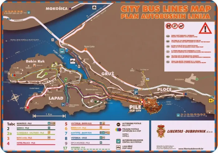
Dubrovnik has a comprehensive bus network connecting all parts of the city through frequent and regular routes.
Each major bus stop displays city bus timetables, which are also available if you download and install the local bus app (which I recommend doing): Libertas app (App Store here).
The local bus service, which operates about 70 buses, covers 9 city and 18 suburban routes. Remember, bus and car traffic are prohibited in the city center. The principal bus station near the city center is located in the Pile area, adjacent to Pile Gate.
Key city bus lines on the Dubrovnik bus map for tourists mainly revolve around Pile Gate:
- Bus No. 6 travels from Pile bus station to Lapad and Babin Kuk, areas known for their hotels and private accommodations.
- Bus No. 4 connects Pile to the Hotel Palace in Lapad.
The main Dubrovnik bus station is in the village of Kantafig, near the Gruz harbor ferry port, approximately 2 km from the city center.
From Gruz Harbor to Pile Gate:
- Buses No. 1A, 1B, 3, and 3A provide service to Pile Gate.
- Bus No. 7 runs to the Lapad and Babin Kuk districts.
- Bus No. 8 heads to Ploce Gate and St. Jakov.
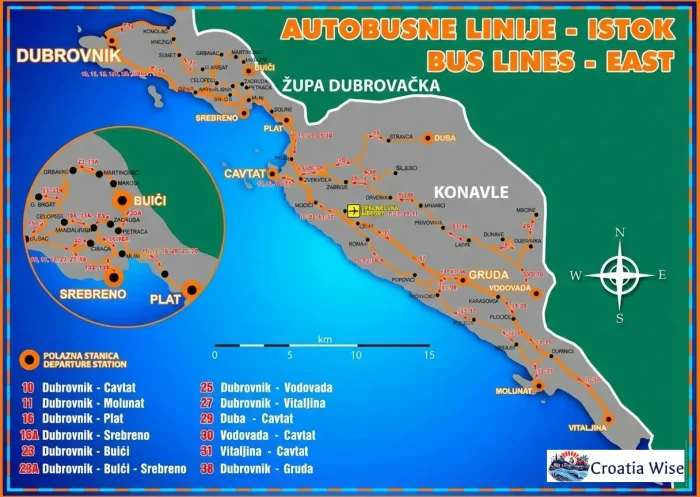
For those looking to explore beyond the city, suburban buses connect Dubrovnik to nearby towns:
- Bus No. 10 maintains a route to Cavtat.
- Bus No. 12 travels to Slano.
- Bus No. 15 heads to Ston.
- Bus No. 21 journeys to Orebic, where you can catch a ferry to Korcula Island.

Also read: Dubrovnik Banje Beach Guide.
The best way to explore Dubrovnik is on foot
The best way to see Dubrovnik is undoubtedly on foot. Dubrovnik is a walkable city and I recommend exploring it on foot – at least the Old Town area, which is anyway a pedestrian zone, making walking the only method of exploration.
Check out my recommended walking tours below:
I love walking in Dubrovnik and I am sure you will too, as you will discover all the countless details and hidden gems that you might miss if you were driving or taking a bus.
From any other part of the city, you can easily reach the Old City’s main entrances, the Pile or Ploce Gates.
A pleasant walk from Gruz Harbor, where many cruise ships dock, to Lapad Bay, another pedestrian-friendly area, takes less than thirty minutes. Additionally, a leisurely forty-minute stroll will bring you to the iconic city walls.
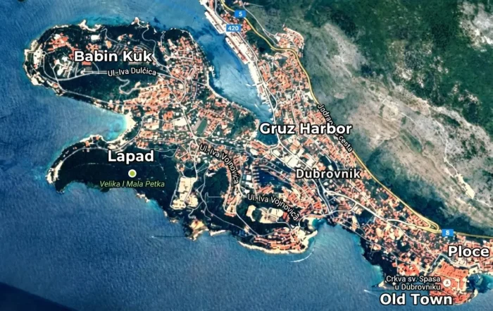
Old Town Map of Dubrovnik

If you’re planning an extended stay here – following my five days in Dubrovnik itinerary, for example – you’ll likely find yourself considering accommodations outside the Old Town walls to keep costs lower.
For those still deciding on the best accommodation type, many of Dubrovnik’s hotels and lodging options are located in neighborhoods outside the Old Town.
The map below highlights popular areas such as Ploce, Lapad, Gruz Harbor, and Babin Kuk, where you can find a range of excellent hotels as well as budget-friendly apartments, B&Bs, and guesthouses.
More Maps of Dubrovnik
If you are arriving by air, the Dubrovnik Airport is about 20 kilometers from the city. Bus transfers to Dubrovnik are synchronized with the arrivals of each regular flight. Here is the map showing the location of the airport in relation to the city center.

Tickets can be purchased directly from the bus driver. And if you plan to visit more of Croatia, check out my guide to public transport in Zagreb.
Hopefully these maps of Dubrovnik and its surroundings will make navigation a lot easier for you and your travel more enjoyable, with no major attractions missed!
And if you love maps in general – and Croatian ones in particular, check out the ones below also: